![](/images/other/stat-length.png)
![Trail Walking Le Hohwald - Du Hohwald au Champ du Feu - Photo](https://media.geolcdn.com/t/1900/400/ext.pjpeg?maxdim=2&url=https%3A%2F%2Fservices.sitytrail.com%2FGeolivesWS%2FDownloadMedia.ashx%3FTrailID%3D109958%26Media%3D5025_1.jpg)
Du Hohwald au Champ du Feu
tracegps
User
![Length](/images/other/stat-length.png)
Length
17.8 km
![Max alt](https://static1.geolcdn.com/siteimages/upload/files/1508320355ic_sort_altitude_max_24dp.png)
Max alt
1103 m
![Uphill gradient](https://static1.geolcdn.com/siteimages/upload/files/1508320355ic_sort_den_pos_24dp.png)
Uphill gradient
642 m
![Km-Effort](/images/other/stat-length.png)
Km-Effort
26 km
![Min alt](https://static1.geolcdn.com/siteimages/upload/files/1508320355ic_sort_altitude_min_24dp.png)
Min alt
567 m
![Downhill gradient](https://static1.geolcdn.com/siteimages/upload/files/1508320355ic_sort_den_neg_24dp.png)
Downhill gradient
646 m
![Boucle](https://static1.geolcdn.com/siteimages/upload/files/16400158638029165_repeat_loop_refresh_sync_direction_icon.png)
Boucle
Yes
Creation date :
2014-12-10 00:00:00.0
Updated on :
2014-12-10 00:00:00.0
![Walking](https://static1.geolcdn.com/sitytour/trail-icons/101.png)
6h00
Difficulty : Very difficult
![Scan this QR Code to open this trail in the SityTrail application](https://capi.geolives.com/qq0zvz2zws4bq2lad0pu/sitytour/trails/109958/qr.png?size=200)
FREE GPS app for hiking
About
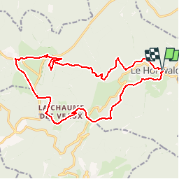
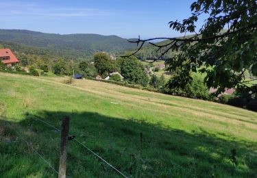
Trail Walking of 17.8 km to be discovered at Grand Est, Bas-Rhin, Le Hohwald. This trail is proposed by tracegps.
Description
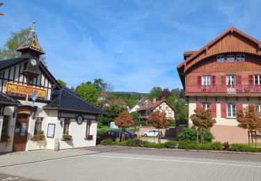
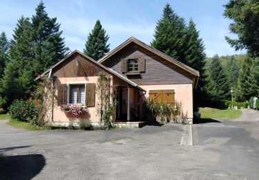
Du Hohwald au Champ du Feu. Des forêts du Hohwald aux chaumes du Champ de Feu en passant par la cascade de l’Andlau. Pour toute information complémentaire sur la randonnée : Comité départemental du Bas Rhin: 9 RUE MEYER 67500 HAGUENAU Tél. : 0388907606
Positioning
Country:
France
Region :
Grand Est
Department/Province :
Bas-Rhin
Municipality :
Le Hohwald
Location:
Unknown
Start:(Dec)
Start:(UTM)
376408 ; 5362511 (32U) N.
Comments
Trails nearby
![Trail Horseback riding Ottrott - 2024-09-03_17h19m14_suuntoapp-HorsebackRiding-2024-09-03T08-25-34Z-track - Photo](https://media.geolcdn.com/t/375/260/83371a81-1c5b-4988-84fb-7fd3471a6a57.jpg&format=jpg&maxdim=2)
![Horseback riding Horseback riding](https://static1.geolcdn.com/sitytour/trail-icons/301.png)
2024-09-03_17h19m14_suuntoapp-HorsebackRiding-2024-09-03T08-25-34Z-track
Horseback riding
Medium
Ottrott,
Grand Est,
Bas-Rhin,
France
![](/images/other/stat-length.png)
18.8 km | 26 km-effort
3h 23min
![](https://static1.geolcdn.com/siteimages/upload/files/16400158638029165_repeat_loop_refresh_sync_direction_icon.png)
Yes
![Trail Walking Le Hohwald - suuntoapp-Hiking-2024-04-27T09-12-29Z - Photo](https://media.geolcdn.com/t/375/260/d8b206f8-0969-498e-bcc6-fd799e0e40cd.jpg&format=jpg&maxdim=2)
![Walking Walking](https://static1.geolcdn.com/sitytour/trail-icons/101.png)
suuntoapp-Hiking-2024-04-27T09-12-29Z
Walking
Medium
Le Hohwald,
Grand Est,
Bas-Rhin,
France
![](/images/other/stat-length.png)
20 km | 31 km-effort
6h 58min
![](https://static1.geolcdn.com/siteimages/upload/files/16400158638029165_repeat_loop_refresh_sync_direction_icon.png)
Yes
![Trail Walking Reichsfeld - 2019-12-28 Marche Reichsfeld Ungersberg Gruckert - Photo](https://media.geolcdn.com/t/375/260/42eae20f-c3f4-4c06-9edb-b597f2c7a1bb.jpg&format=jpg&maxdim=2)
![Walking Walking](https://static1.geolcdn.com/sitytour/trail-icons/101.png)
2019-12-28 Marche Reichsfeld Ungersberg Gruckert
Walking
Very easy
Reichsfeld,
Grand Est,
Bas-Rhin,
France
![](/images/other/stat-length.png)
12.2 km | 20 km-effort
3h 5min
![](https://static1.geolcdn.com/siteimages/upload/files/16400158638029165_repeat_loop_refresh_sync_direction_icon.png)
Yes
![Trail Walking Le Hohwald - Tour du Hohwald - Photo](https://media.geolcdn.com/t/375/260/ext.jpg?maxdim=2&url=https%3A%2F%2Fstatic1.geolcdn.com%2Fsiteimages%2Fupload%2Ffiles%2F1553511878bg_sport_marche.png)
![Walking Walking](https://static1.geolcdn.com/sitytour/trail-icons/101.png)
Tour du Hohwald
Walking
Medium
(1)
Le Hohwald,
Grand Est,
Bas-Rhin,
France
![](/images/other/stat-length.png)
8 km | 11.3 km-effort
2h 26min
![](https://static1.geolcdn.com/siteimages/upload/files/16400158638029165_repeat_loop_refresh_sync_direction_icon.png)
Yes
![Trail Walking Ottrott - 2013-12-29 Marche Mt Ste Odile Maennelstein Birkenfels - Photo](https://media.geolcdn.com/t/375/260/ext.jpg?maxdim=2&url=https%3A%2F%2Fstatic1.geolcdn.com%2Fsiteimages%2Fupload%2Ffiles%2F1553511878bg_sport_marche.png)
![Walking Walking](https://static1.geolcdn.com/sitytour/trail-icons/101.png)
2013-12-29 Marche Mt Ste Odile Maennelstein Birkenfels
Walking
Medium
(1)
Ottrott,
Grand Est,
Bas-Rhin,
France
![](/images/other/stat-length.png)
10.8 km | 15.4 km-effort
3h 24min
![](https://static1.geolcdn.com/siteimages/upload/files/16400158638029165_repeat_loop_refresh_sync_direction_icon.png)
Yes
![Trail Walking Le Hohwald - Hohwald - Rothlach - Neuntelstein - Photo](https://media.geolcdn.com/t/375/260/0ea7410a-d32d-4905-9369-a48f058188e6.jpg&format=jpg&maxdim=2)
![Walking Walking](https://static1.geolcdn.com/sitytour/trail-icons/101.png)
Hohwald - Rothlach - Neuntelstein
Walking
Medium
(1)
Le Hohwald,
Grand Est,
Bas-Rhin,
France
![](/images/other/stat-length.png)
15.8 km | 22 km-effort
4h 28min
![](https://static1.geolcdn.com/siteimages/upload/files/16400158638029165_repeat_loop_refresh_sync_direction_icon.png)
Yes
![Trail On foot Le Hohwald - Champ du feu début - Photo](https://media.geolcdn.com/t/375/260/f322735a-2e98-4355-b067-4845daa855de.jpg&format=jpg&maxdim=2)
![On foot On foot](https://static1.geolcdn.com/sitytour/trail-icons/100.png)
Champ du feu début
On foot
Easy
Le Hohwald,
Grand Est,
Bas-Rhin,
France
![](/images/other/stat-length.png)
6.8 km | 9.6 km-effort
2h 10min
![](https://static1.geolcdn.com/siteimages/upload/files/16400158638029165_repeat_loop_refresh_sync_direction_icon.png)
No
![Trail Walking Le Hohwald - le hohwald, boucle](https://media.geolcdn.com/t/375/260/cc43b1d5-9e0d-477b-9cf7-84cc19342b6e.jpg&format=jpg&maxdim=2)
![Walking Walking](https://static1.geolcdn.com/sitytour/trail-icons/101.png)
le hohwald, boucle "petite ceinture"
Walking
Easy
(1)
Le Hohwald,
Grand Est,
Bas-Rhin,
France
![](/images/other/stat-length.png)
3.4 km | 4.8 km-effort
55min
![](https://static1.geolcdn.com/siteimages/upload/files/16400158638029165_repeat_loop_refresh_sync_direction_icon.png)
Yes
![Trail Walking Le Hohwald - Hohwald (ter) - Photo](https://media.geolcdn.com/t/375/260/3da381bb-faf8-430b-b807-40072fd051a1.jpg&format=jpg&maxdim=2)
![Walking Walking](https://static1.geolcdn.com/sitytour/trail-icons/101.png)
Hohwald (ter)
Walking
Difficult
Le Hohwald,
Grand Est,
Bas-Rhin,
France
![](/images/other/stat-length.png)
11.2 km | 15.6 km-effort
3h 31min
![](https://static1.geolcdn.com/siteimages/upload/files/16400158638029165_repeat_loop_refresh_sync_direction_icon.png)
Yes
Manque les indications sur le fléchage du club vosgiens. Le parcours total fait 21 km pour 5h de marche, 30 min de casse croûte inclus. Cette randonnée est incontournable